


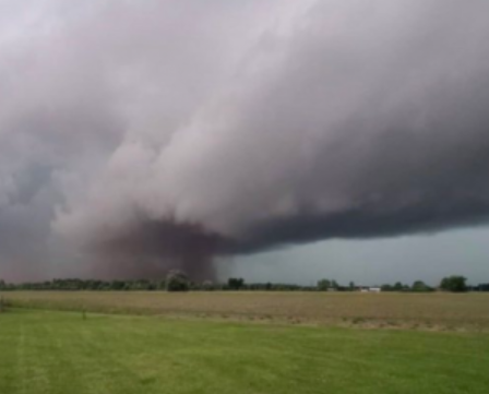
Environment Canada has confirmed two tornadoes that moved through the London area last night that damaged trees, hydro poles and nearby structures. (pictured a tornado in the Glencoe-area, June 10)

The first tornado was reported in Newbury around 7:50 p.m and approximately 5 minutes later what is believed to be the same tornado was spotted in Glencoe.

Reports of a second tornado began to come in from the Belmont-area around 8:30 pm. No injuries have been reported.
Despite the widespread damage, a spokesperson from the weather agency said that the pair of tornadoes are believed to have been on the lower end of the Enhanced Fujita (EF) Scale coming in at an EF0 or at most an EF1 which is very low on the scale.
The tornadoes appeared as a line of severe thunderstorms moved across southwestern Ontario bringing intense lightning, hail, torrential downpours, and wind gusts up to 120 km/h. The system pushed out hot, humid air that had the region under a heat warning for the past two days.
As for the Niagara Region, although we did not get tornadoes, it looks like we had record heat. According to Environment Canada’s website a measurement of 32.6 degrees yesterday in St. Catharines beat the previous highest temperature recorded back in 1976 of 31.7°C.
The forecast for today is a much calmer and cooler one with a mix of sun and cloud and a daytime high of 22 C. The average seasonal daytime temperature for this time of year is 23.3C.
To receive similar content, “Like” us on Facebook @ https://www.facebook.com/niagarabuzz.ca